
Rugged Handheld GPS for Hiking with Multi-GNSS and USA Topo Maps: In-Depth Review
This review explores the Handheld GPS for Hiking, Rugged and Waterproof Handheld GPS Navigator, 3.2" Sunlight Readable Screen, Compact Satellite Handheld GPS with USA Topo Map, Multi-GNSS Support, Extra Battery Life, focusing on its rugged design, IP66 water resistance, multi-GNSS satellite support, preloaded USA topo maps, 3-axis compass, barometric altimeter, and extended battery performance. We examine how its 3.2-inch sunlight-readable display, 32 GB internal memory, and waypoint/track navigation features perform on real hiking and backcountry trips. The article also analyzes usability, strengths, and trade-offs compared to relying on a smartphone or more advanced GPS units, helping hikers, backpackers, and outdoor enthusiasts decide if this compact navigator is the right fit for their navigation needs.
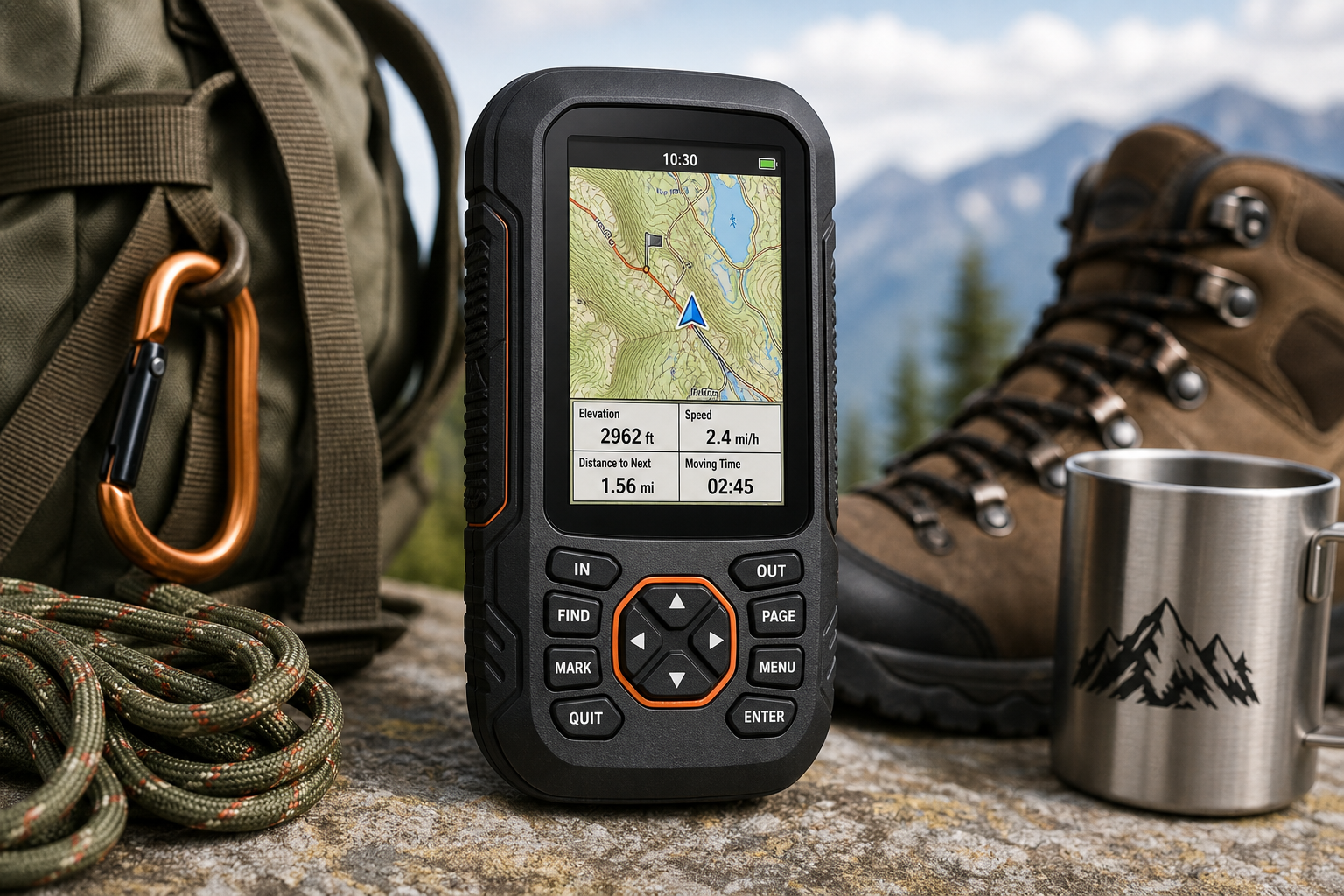
Product Context
The [Handheld GPS for Hiking, Rugged and Waterproof Handheld GPS Navigator, 3.2" Sunlight Readable Screen, Compact Satellite Handheld GPS with USA Topo Map, Multi-GNSS Support, Extra Battery Life] is a compact, button-operated GPS unit aimed at hikers, campers, anglers, and anyone who needs reliable off-grid navigation.
It combines a 3.2-inch sunlight-readable color display with an IP66-rated rugged, water-resistant housing designed to handle dust, rain, and rough handling on the trail. Under the hood, it supports multiple satellite constellations (GPS + Galileo + BeiDou + QZSS) for better positional accuracy than GPS-only devices and comes preloaded with USA topographic maps, backed by 32 GB of internal storage for additional map data.
Core capabilities include:
- Multi-GNSS support for improved accuracy and signal reliability in challenging environments
- Preloaded USA topo maps for hiking and camping
- 3-axis electronic compass and barometric altimeter
- Waypoint, route, and track recording for navigation and trip logging
- Rechargeable battery rated for up to 36 hours of use per charge
Positioned as a dedicated handheld navigator, this device targets users who want something more robust and focused than a smartphone, but simpler and more affordable than high-end mapping GPS units.
Feature Breakdown
Rugged, Waterproof Design
The housing is built around outdoor use, with an IP66 water-resistance rating. This means it is dust-tight and can withstand powerful water jets, making it suitable for heavy rain, splashes, and muddy conditions. It is not intended for full submersion, but the rating is more than adequate for typical hiking, backpacking, or fieldwork scenarios.
The anti-slip exterior aids grip when hands are wet or gloved, and the compact form factor keeps it easy to stow in a pocket or clip to a harness. Included accessories typically cover a hanging rope/lanyard, USB cable, plug, and user manual, which simplifies getting started.
3.2" Sunlight-Readable Display
A key feature is the 3.2-inch color LCD display optimized for outdoor visibility. The screen is marketed as “sunlight readable,” which, in practice, means the combination of brightness and anti-reflective properties should make maps and data legible in bright midday sun.
The display size strikes a balance between portability and readability. It’s larger than many entry-level handheld GPS units while remaining compact enough for single-handed operation. The unit relies on physical buttons (and in some listings, limited touch support), which is a plus in rain, cold, or when gloves make capacitive touchscreens unreliable.
Multi-GNSS Satellite Support
This handheld GPS supports multiple satellite navigation systems:
- GPS (United States)
- Galileo (European Union)
- BeiDou (China)
- QZSS (regional augmentation for the Asia-Pacific region)
Using multiple constellations increases the number of satellites in view at any given time, allowing the device to maintain a lock in narrower canyons, dense tree cover, or urban edges more effectively than GPS-only devices. The advertised location precision is within roughly 6 feet under good conditions, which is suitable for hiking navigation, marking campsites, or returning to a trail or vehicle.
USA Topo Maps and Storage
The unit comes preloaded with USA topographic maps, so you can start navigating trails and terrain right away. Topo maps are essential for backcountry navigation because they show contour lines, elevation, and natural features like rivers, ridges, and valleys.
With 32 GB of internal memory, there is ample room for additional map data, such as regional or more detailed maps where supported. While this GPS is not tied into a specific manufacturer’s premium mapping ecosystem, the onboard capacity ensures you can store large coverage areas without constantly swapping data.
Sensors: 3-Axis Compass and Barometric Altimeter
The integrated 3-axis electronic compass provides directional headings even when you’re standing still, unlike GPS-based heading which requires movement. This is especially helpful when orienting the device to a paper map or deciding on a direction at a junction.
The barometric altimeter uses air pressure to estimate elevation, which can be more responsive and precise than GPS altitude alone when calibrated. Combined with topo maps, this improves situational awareness on steep terrain, ridgelines, and passes.
Waypoints, Routes, and Track Recording
The device can:
- Save waypoints for campsites, trailheads, fishing spots, water sources, and other points of interest
- Build routes connecting multiple waypoints
- Record tracks as you hike, forming a breadcrumb trail you can follow back to your starting point
This functionality is essential for off-trail travel, remote hunting or fishing, or simply documenting your hikes for later analysis or sharing.
Power and Battery Life
A built-in rechargeable battery is rated for up to 36 hours of operation on a full charge, depending on settings such as backlight level, active tracking, and GNSS mode. Charging is done via a standard USB-C cable, which is convenient for modern power banks and chargers.
For multi-day trips, pairing the GPS with a compact power bank extends its range significantly. The long single-charge runtime already compares favorably with modern smartphones running mapping apps with the screen frequently on.
Performance Insights
Satellite Lock and Accuracy
Thanks to multi-GNSS support, this handheld GPS is better positioned than basic GPS-only devices to maintain signal integrity in real-world hiking environments. In wooded valleys or near cliffs where satellite visibility is limited, the extra constellations can make the difference between a stable fix and intermittent signal loss.
While it does not belong to the top tier of survey-grade devices, its claimed accuracy of around 6 feet is more than adequate for trail navigation, waypoint marking, and backtracking routes. Frequent hikers will appreciate the ability to confidently return to a previously saved campsite, vehicle, or water source.
Map Readability and Screen Use Outdoors
The combination of a 3.2-inch screen and outdoor-oriented brightness gives this device an edge over smaller, dimmer units. Topo lines, trails, and waypoints remain legible even in bright light when the backlight is properly adjusted.
Because it relies heavily on physical buttons, the user can zoom, pan, and navigate menus without depending on touch input, which is a major advantage in rain, snow, or when wearing thicker gloves.
Battery Endurance on the Trail
Under moderate use—periodic screen checks, continuous tracking, and standard brightness—the rated 36-hour battery life suggests it can cover several day hikes or a full weekend trip on a single charge. Power-conscious users can extend that life by dimming the screen, enabling power-saving modes, or reducing the frequency of track logging.
This endurance level makes the handheld GPS a reliable navigation backup to a smartphone, which typically drains far faster when GPS, screen, and offline mapping apps are used extensively.
Reliability vs. Smartphone Apps
Compared with smartphones running mapping apps:
- This handheld is more robust in poor weather (thanks to IP66 water resistance and drop-friendly design).
- The battery is dedicated to navigation, so you’re not sharing power with other apps, calls, or photography.
- Physical controls and a sunlight-readable display maintain usability in conditions that easily overwhelm typical consumer phones.
For most hikers, this device will complement rather than fully replace a smartphone, serving as a reliable backup and primary navigator in remote areas.
Usability
Setup and First Use
Out of the box, the unit is straightforward:
- Charge the device via USB-C.
- Power on and acquire satellite lock in an open outdoor area.
- Explore preloaded USA topo maps and confirm your location.
- Set up key screens and data fields (e.g., elevation, speed, distance to next waypoint).
The presence of preloaded topo maps eliminates the initial barrier of sourcing and installing basic coverage, which can be daunting for new GPS users.
Interface and Controls
The interface is menu-driven and optimized for button operation. While it may appear less modern than touchscreen-heavy devices, buttons offer more precise control in rugged conditions. Common tasks such as marking a waypoint, starting/stopping track recording, or switching map views become quick once you learn the button layout.
Users accustomed only to smartphone apps may find the learning curve steeper at first, but dedicated GPS users will likely appreciate the predictability and tactile feedback of the hardware controls.
Portability and Handling
The handheld’s compact and lightweight design makes it easy to carry:
- Fits in larger pockets, hip-belt pockets, or small chest pouches
- Can be clipped to a strap or lanyard for quick access on the move
The anti-slip housing provides extra security when handling the device with cold or wet hands.
PC Connectivity and Data Management
Via USB, you can typically:
- Offload GPX tracks and waypoints for archiving, analysis, or sharing
- Load additional map files where supported
This makes the device a practical tool for users who like to log their hikes, maintain a library of favorite routes, or plan trips on a computer before heading out.
Trade-offs
No device is perfect, and this handheld GPS makes a few clear trade-offs that buyers should weigh carefully.
Pros
- Rugged and water-resistant (IP66) construction suitable for harsh outdoor conditions
- Multi-GNSS support (GPS, Galileo, BeiDou, QZSS) for improved positioning accuracy and reliability
- 3.2-inch sunlight-readable display that remains usable under bright sun
- Preloaded USA topo maps for immediate out-of-the-box navigation
- 3-axis compass and barometric altimeter for better orientation and elevation awareness
- Up to 36 hours of battery life per charge, with convenient USB-C charging
- Physical button controls that work well with gloves and in wet conditions
Cons
- IP66 rating is strong for rain and splashes but not designed for full immersion, so paddlers or canyoners may need additional protection
- Interface may feel less polished than premium-brand GPS units with advanced UI design
- Limited ecosystem compared with major GPS brands; map management and software tools may be more basic
- The 3.2-inch screen, while larger than some entry-level devices, is smaller than high-end models, which can mean more frequent panning and zooming on complex maps
- Requires a period of familiarization for users new to handheld GPS interfaces, especially those migrating from smartphone-only navigation
Conclusion
The [Handheld GPS for Hiking, Rugged and Waterproof Handheld GPS Navigator, 3.2" Sunlight Readable Screen, Compact Satellite Handheld GPS with USA Topo Map, Multi-GNSS Support, Extra Battery Life] delivers a focused blend of ruggedness, battery endurance, and navigation capability tailored to hikers and outdoor enthusiasts who want a reliable, dedicated GPS unit.
Its combination of multi-GNSS support, preloaded USA topo maps, 3-axis compass, barometric altimeter, and a sunlight-readable 3.2-inch screen makes it well suited for day hikes, backpacking, and general backcountry exploration. The IP66-rated housing and long battery life give it an advantage over smartphones in harsh or extended-use conditions.
On the other hand, users seeking deep integration with a premium mapping ecosystem, very large screens, or advanced connectivity features may still gravitate toward higher-end branded devices. Likewise, those who rarely leave well-marked trails and are comfortable relying on smartphone apps might not fully utilize the strengths of a dedicated handheld navigator.
Overall, this handheld GPS is a compelling option for hikers, hunters, anglers, and field users who prioritize rugged durability, accurate positioning, and dependable battery life in a compact form factor. For anyone looking to add a robust, stand-alone navigator to their outdoor kit, this model is worth serious consideration.