
Garmin Montana 710 Review: A Rugged GPS Navigator for Hiking, Off-Roading, and Outdoor Navigation
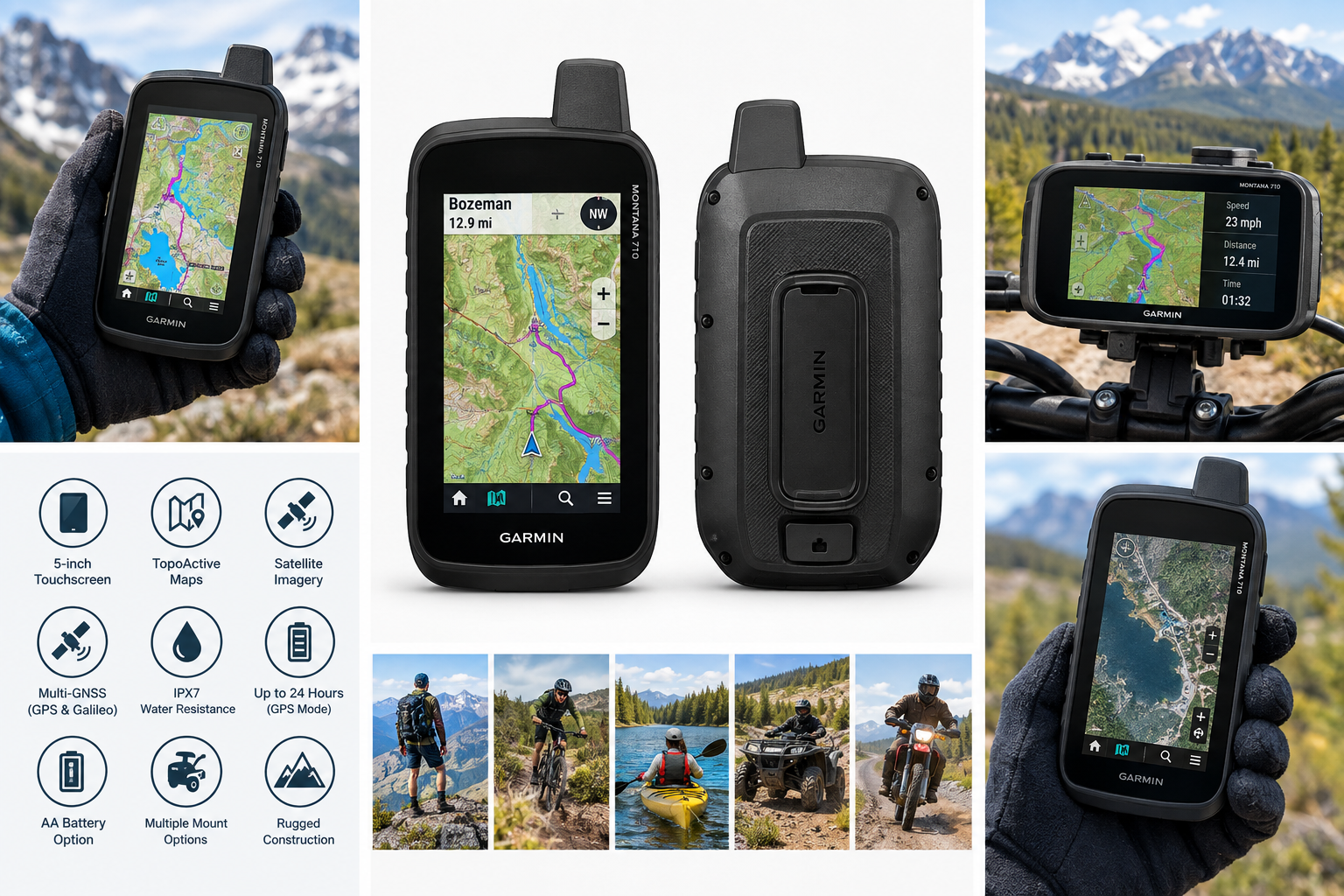
The Garmin Montana 710 is a rugged handheld GPS navigator designed for hiking, off-road travel, mountain biking, boating, and other outdoor activities. Its large glove-friendly 5-inch touchscreen, preloaded TopoActive maps, satellite imagery support, multi-GNSS positioning, durable construction, and flexible mounting options make it a capable navigation tool. This review examines its mapping features, display, battery performance, usability, durability, and key trade-offs, including its substantial size and the absence of built-in inReach satellite communication.
Product Context
The Garmin Montana 710 is a large-format handheld GPS navigator built for users who need more screen space and greater durability than a typical smartphone or compact GPS unit can provide. It is intended for activities such as hiking, mountain biking, camping, hunting, boating, motorcycle travel, ATV riding, and other off-road adventures.
The Montana 710 combines a 5-inch color touchscreen with outdoor-focused mapping and navigation tools. It is designed to work both as a handheld device and as a vehicle-mounted navigator when paired with compatible mounts, which are sold separately. Unlike the Montana 710i and 760i, the Montana 710 does not include built-in inReach satellite messaging or SOS functionality.
Feature Breakdown
Large Glove-Friendly Touchscreen
The 5-inch dual-orientation display is one of the Montana 710's defining features. Its 480 x 800 resolution provides a broad viewing area for maps, routes, elevation information, and navigation data. The touchscreen is designed for outdoor use and can be operated while wearing many types of gloves.
The larger display is useful when following complex trails or reviewing maps while traveling in a vehicle. It also reduces the need to repeatedly zoom or pan compared with smaller handheld GPS units. However, the larger body makes the device less pocket-friendly than compact navigators.
TopoActive Maps
The Montana 710 includes preloaded TopoActive maps, with coverage depending on the region where the unit is purchased. These maps are designed for outdoor navigation and can include roads, trails, paths, waterways, terrain features, points of interest, and elevation information.
Additional TopoActive regions can be downloaded through the device's map management tools. Users can also add compatible mapping products, such as City Navigator road maps or marine charts, when their intended activity requires more specialized coverage.
Satellite Imagery
The device supports direct downloads of high-resolution satellite imagery over Wi-Fi. Satellite views can help users identify terrain features, clearings, roads, trail junctions, and potential waypoints that may not be obvious on a conventional topographic map.
Satellite imagery is particularly useful for route planning and visual orientation, although downloading and managing additional map data requires storage space and a reliable Wi-Fi connection.
Multi-GNSS Positioning
The Montana 710 can use multiple global navigation satellite systems, including GPS and Galileo. Access to more than one satellite network can help improve positioning availability in challenging environments, such as mountainous terrain, forests, and areas with partial sky obstruction.
As with any satellite-based navigator, accuracy can vary according to tree cover, terrain, atmospheric conditions, and the surrounding environment.
Rugged Construction
The device uses a chemically strengthened glass lens and is rated IPX7 for water resistance. It is also tested against selected military standards for thermal, shock, and vibration resistance. These characteristics make it better suited to demanding outdoor conditions than a standard smartphone.
The rugged construction adds confidence for use on trails, boats, motorcycles, and ATVs, but it also contributes to the Montana 710's considerable weight and size.
Battery Options
The Montana 710 includes a rechargeable lithium-ion battery and supports up to 24 hours of battery life in GPS mode under ideal conditions. Expedition mode can extend operation substantially, with a rated runtime of up to 440 hours. The device can also support three AA batteries as an alternative power source, although the rechargeable battery is the recommended option for regular use.
Actual runtime depends on display brightness, satellite conditions, wireless connectivity, map usage, temperature, and the amount of time spent recording tracks or navigating routes.
Performance Insights
The Montana 710's strongest performance advantage is its combination of screen size, mapping capability, and ruggedness. The large display makes route lines and map details easier to read, especially when the device is mounted on a motorcycle, ATV, boat, or vehicle dashboard.
TopoActive maps provide a useful starting point for trails and outdoor travel, while satellite imagery adds another layer of visual information. The ability to switch between map types and download additional regional data gives the device flexibility for users who travel across different environments.
The unit is also better suited to extended trips than many smartphone-based navigation setups. It does not depend on cellular coverage for its core GPS functions, and its dedicated design avoids some of the battery and durability limitations associated with using a phone in wet, dusty, or cold conditions.
However, the Montana 710 is primarily a navigation device rather than a communication device. It can determine location, record tracks, and guide users along routes, but it does not provide the two-way satellite messaging and SOS capabilities found in Garmin's inReach-equipped Montana models.
Usability
The touchscreen interface is straightforward for users familiar with Garmin outdoor products. Large controls, map zooming, route management, waypoint creation, and activity profiles are accessible from the main interface. The screen can be used in portrait or landscape orientation, allowing users to adapt it to handheld or mounted operation.
Integration with the Garmin Explore app can support trip planning, route management, waypoint organization, and activity review. Wi-Fi connectivity also simplifies software and map updates when an appropriate network is available.
The device's size is an advantage for visibility but a drawback for portability. It is comfortable to read while mounted or held in the hand, yet it may feel bulky during lightweight hiking trips. Users who prioritize minimal pack weight may prefer a smaller handheld GPS, while riders and vehicle users may appreciate the large control layout.
Trade-offs
Advantages
- Large 5-inch touchscreen with portrait and landscape orientation
- Glove-friendly controls for outdoor use
- Preloaded TopoActive maps with downloadable regional coverage
- Support for high-resolution satellite imagery
- Multi-GNSS positioning using GPS and Galileo
- Rugged construction with IPX7 water resistance
- Long battery life with rechargeable and AA battery options
- Compatible with multiple vehicle and activity-specific mounts
- Useful for hiking, boating, cycling, motorcycles, ATVs, and overlanding
Limitations
- Larger and heavier than compact handheld GPS units
- Built-in inReach satellite messaging and SOS are not included
- Some advanced maps and mapping services require separate purchases or subscriptions
- Mounting accessories are sold separately
- Touchscreen operation may be less convenient in heavy rain, thick gloves, or very cold conditions
- Battery estimates can decrease significantly with frequent screen use, wireless features, and poor satellite visibility
Conclusion
The Garmin Montana 710 is a capable rugged GPS navigator for users who value a large display, detailed outdoor maps, long battery life, and flexible mounting options. Its preloaded TopoActive maps, satellite imagery support, durable construction, and multi-GNSS positioning make it well suited to hiking, off-road travel, boating, motorcycle navigation, and other demanding outdoor activities.
Its main compromises are its substantial size, the additional cost of optional mapping and accessories, and the lack of built-in inReach communication. For users who need a dedicated navigation device with a highly visible screen and strong outdoor durability, the Montana 710 is a well-rounded choice. Those who need emergency satellite messaging should consider an inReach-equipped alternative in Garmin's Montana range.