
Garmin GPSMAP H1 Premium GPS Navigator Bundle: Rugged Handheld GPS Review
The Garmin GPSMAP H1 Premium GPS Navigator Bundle is a rugged handheld GPS designed for hiking, hunting, backpacking, and other outdoor activities. It combines a 3.5-inch sunlight-readable touchscreen with physical buttons, multi-band GPS and multi-GNSS positioning, preloaded topographic maps, ABC sensors, long battery life, an LED flashlight, and IP67-rated durability. This review examines its navigation features, included accessories, ideal users, practical benefits, and important limitations.
4(Based on 7 reviews)
Garmin GPSMAP H1 Premium GPS Navigator Bundle | For Hiking, Hunting & Outdoor Navigation | Color Touchscreen | Built-In Flashlight | Preloaded Maps | Long Battery Life
SHOP NOW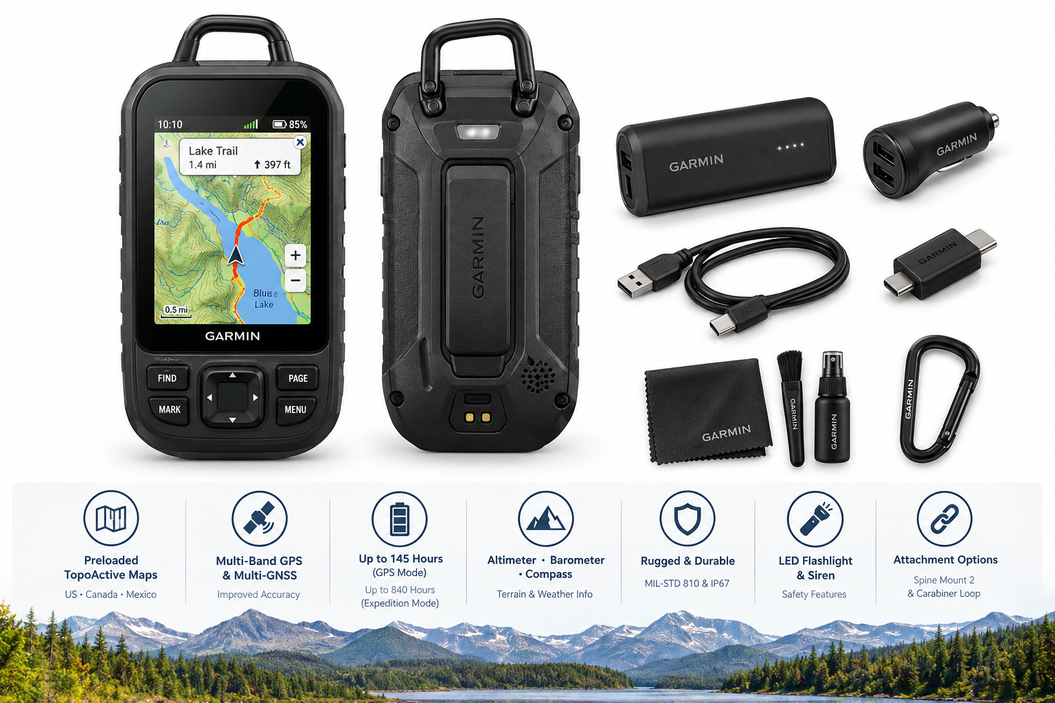
Product Summary
The Garmin GPSMAP H1 Premium GPS Navigator Bundle is a dedicated handheld GPS built for outdoor navigation in demanding environments. It combines a 3.5-inch color touchscreen with physical buttons, giving users multiple ways to interact with maps in changing weather or while wearing gloves.
The device supports multi-band GPS and multi-GNSS positioning for improved location accuracy in areas where satellite visibility may be limited, such as dense forests, deep valleys, or urban canyons. It also includes an altimeter, barometer, and compass to provide additional terrain and weather-related information.
Garmin lists up to 145 hours of battery life in GPS mode and up to 840 hours in Expedition mode with SatIQ technology. The unit includes preloaded TopoActive maps for the United States, Canada, and Mexico, with additional satellite imagery available for download through Wi-Fi.
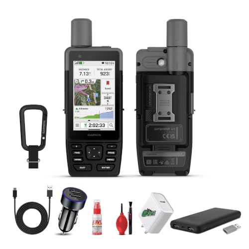
This bundle also includes a USB 3.0-to-USB-C adapter, USB charging adapter, power-bank battery, USB-A-to-USB-C cable, cleaning kit, and two-port USB car adapter.
Target Users
The GPSMAP H1 is best suited to:
- Hikers and backpackers who need dedicated navigation away from cellular coverage.
- Hunters and outdoor explorers traveling through remote or unfamiliar terrain.
- Users who prefer physical navigation equipment instead of relying exclusively on a smartphone.
- People who need extended battery life for multi-day trips.
- Adventurers who value rugged construction, water resistance, and attachment options.
- Users who want topographic maps and satellite imagery in a standalone handheld device.
It may be more than necessary for casual navigation, short day trips, or users who primarily navigate in areas with reliable cellular service.
Main Benefits
Hybrid Touchscreen and Button Controls
The combination of a touchscreen and physical buttons provides flexibility in the field. The touchscreen can make map interaction more intuitive, while physical controls may be more dependable in wet, cold, or gloved conditions.
Accurate Outdoor Positioning
Multi-band GPS and multi-GNSS support are designed to improve positioning reliability in challenging environments. The built-in altimeter, barometer, and compass add useful information for route planning, elevation awareness, and general orientation.
Long Battery Runtime
The listed battery performance is a major strength for extended trips. GPS mode provides substantial operating time, while Expedition mode is intended to conserve power during longer journeys when frequent position updates are not required.
Detailed Mapping Support
Preloaded TopoActive maps provide terrain contours, elevations, and points of interest across the United States, Canada, and Mexico. Wi-Fi connectivity allows compatible satellite imagery to be downloaded for additional route-planning detail.
Rugged Construction
The GPSMAP H1 is described as meeting MIL-STD 810 testing standards and carrying an IP67 rating for dust and water resistance. These features make it better suited to outdoor use than a typical consumer smartphone, although they do not eliminate the need for reasonable care.
Useful Emergency and Carry Features
A built-in LED flashlight and loud siren add practical safety functions. Spine Mount 2 compatibility and a removable carabiner loop provide flexible ways to attach the device to a backpack or other gear.
Key Considerations
- The device is designed primarily for outdoor navigation, so its specialized features may be unnecessary for ordinary road trips or urban directions.
- Map coverage and available imagery should be reviewed for the regions where the device will be used.
- The 3.5-inch screen is useful for a handheld GPS but remains smaller than a smartphone or tablet display.
- Touchscreen controls can be less convenient in heavy rain, with thick gloves, or in conditions where physical buttons are preferable.
- Satellite imagery downloads and some connected functions require Wi-Fi or a compatible smartphone connection.
- The bundle includes several charging accessories, but buyers should confirm that the included items match their preferred travel and charging setup.
- Battery-life figures depend on operating mode, satellite conditions, screen use, sensors, and other settings.
- A dedicated GPS improves navigation independence but should not replace basic route planning, emergency preparation, or traditional backup navigation skills.
Pros
- Hybrid touchscreen and physical-button interface.
- Multi-band GPS and multi-GNSS support.
- Preloaded topographic maps for the United States, Canada, and Mexico.
- Long listed battery life for extended outdoor trips.
- Expedition mode designed for reduced power consumption.
- Built-in altimeter, barometer, and compass.
- Sunlight-readable, scratch-resistant display.
- MIL-STD 810 testing and IP67-rated protection.
- Built-in LED flashlight and siren.
- Spine Mount 2 compatibility and removable carabiner loop.
- Bundle includes multiple charging and travel accessories.
Cons
- The specialized feature set may be excessive for casual users.
- The display is relatively compact for detailed map viewing.
- Connected features and satellite imagery downloads depend on compatible connectivity.
- Battery performance varies significantly by mode and usage conditions.
- The added bundle accessories may be less useful to buyers who already own compatible charging equipment.
- Dedicated handheld GPS operation requires learning Garmin's interface and mapping workflow.
Alternatives
For shoppers comparing navigation setups, the main alternatives are different device types rather than a single replacement product. A smartphone-based navigation system can provide a larger display and familiar apps, but it generally depends more heavily on battery capacity, protection, downloaded maps, and accessory support. A simpler handheld GPS may be easier to operate and less expensive to equip, but it may provide fewer mapping, connectivity, and safety features.
Within this product category, buyers should also compare the Garmin GPSMAP H1 with standalone configurations, communication-enabled devices, and other rugged handheld navigators based on satellite accuracy, map coverage, battery requirements, emergency tools, display controls, and compatibility with existing outdoor gear.
Conclusion
The Garmin GPSMAP H1 Premium GPS Navigator Bundle is a capable handheld navigation system for users who regularly travel beyond reliable cellular coverage. Its strongest features are the hybrid control layout, multi-band positioning, topographic mapping, long battery life, rugged construction, and practical safety tools.
The device is most compelling for hikers, hunters, backpackers, and outdoor explorers who need dependable navigation over multiple days. Its compact display, specialized interface, and reliance on connected features for some mapping functions mean it is not the ideal choice for every traveler. For serious outdoor use, however, the GPSMAP H1 offers a well-rounded combination of navigation accuracy, durability, and endurance.