
Garmin eTrex 32x Review: A Rugged Handheld GPS for Hiking and Outdoor Navigation
The Garmin eTrex 32x is a compact handheld GPS navigator designed for hiking, geocaching, cycling, boating, and other outdoor activities. It combines a rugged IPX7-rated design with a sunlight-readable color display, preloaded TopoActive maps, a 3-axis compass, barometric altimeter, wireless connectivity, and support for expandable storage. Its button-based interface and replaceable AA batteries make it practical for users who prioritize reliability and long field use over smartphone-style convenience.

4.2(Based on 689 reviews)
Garmin eTrex 32x, Rugged Handheld GPS Navigator
SHOP NOW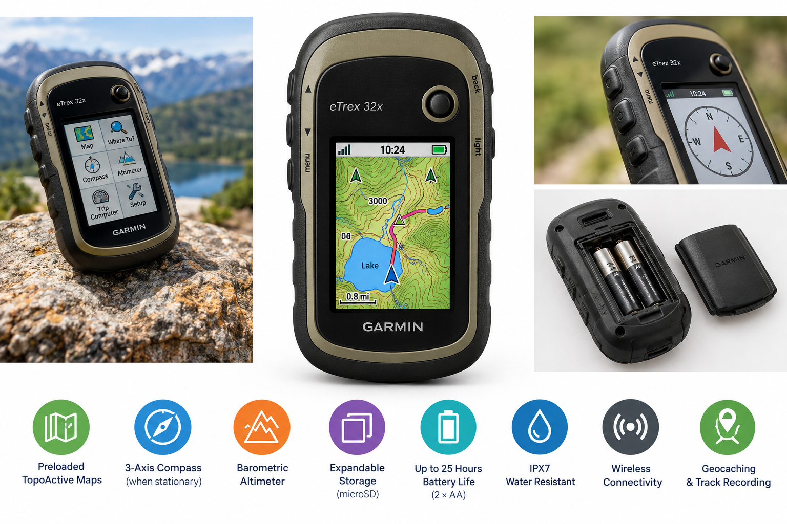
Product Context
The Garmin eTrex 32x is a dedicated handheld GPS designed for outdoor navigation. Rather than relying on cellular coverage or a smartphone battery, it provides standalone positioning, mapping, waypoint management, route planning, and track recording in a compact body.
The eTrex 32x is positioned above the closely related eTrex 22x by adding a 3-axis electronic compass and barometric altimeter. It is intended for hikers, geocachers, cyclists, hunters, boaters, and travelers who need a durable navigation device that can operate away from reliable mobile service.
Feature Breakdown
Color Display and Physical Controls
The device uses a 2.2-inch transflective color TFT display with a 240 x 320 pixel resolution. Its transflective design is intended to remain readable in bright outdoor conditions, while the physical buttons allow operation without relying on a touchscreen.
The button-based interface is useful in wet conditions, when wearing gloves, or when the device is mounted to a bicycle or vehicle. However, the small screen and traditional menu system are less immediately intuitive than modern smartphone navigation apps.
Built-In Mapping and Storage
The eTrex 32x includes preloaded TopoActive maps and supports additional map storage through a microSD card. Garmin lists 8GB of internal memory, along with capacity for up to 2,000 waypoints, 200 routes, 10,000 track points, and 200 saved tracks.
The mapping system supports basic route planning and navigation, while more detailed road navigation may require compatible optional mapping. Users who frequently travel across different regions may benefit from adding a microSD card for supplementary maps and route data.
Compass and Barometric Altimeter
A key advantage of the eTrex 32x is its integrated 3-axis compass, which can provide directional information even when the device is not moving. The barometric altimeter can help estimate elevation changes, making it useful for hiking and terrain tracking.
These sensors add practical value for outdoor navigation, although readings can require calibration and may be influenced by environmental conditions. They are best viewed as navigation aids rather than precision surveying instruments.
Battery and Durability
The unit uses two AA batteries and is rated for up to 25 hours of battery life under suitable operating conditions. Replaceable batteries are convenient for extended trips because users can carry spares instead of depending on access to a power bank or electrical outlet.
With an IPX7 water-resistance rating, the eTrex 32x is designed to withstand exposure to rain and brief immersion. Its compact body measures approximately 2.1 by 4.0 by 1.3 inches and weighs about 5 ounces with batteries, making it relatively easy to carry or mount.
Wireless Connectivity and Outdoor Functions
Wireless connectivity supports compatible Garmin accessories and data features, while paperless geocaching support allows users to work with geocache information directly on the device. The eTrex 32x also supports track recording, waypoint marking, route management, and TracBack-style navigation functions.
Performance Insights
The eTrex 32x is best suited to deliberate, waypoint-based navigation rather than fast, visually rich turn-by-turn guidance. Its dedicated GPS hardware can be valuable in remote areas where cellular coverage is limited or unavailable, and the color display provides more map context than basic monochrome handheld GPS units.
Battery performance is one of its strongest practical qualities. Two replaceable AA batteries provide a straightforward power solution for day hikes and longer trips. Actual runtime can vary depending on backlight use, navigation activity, temperature, battery type, and wireless features.
The device is also well suited to recording routes and retracing previous tracks. Its compass and altimeter provide useful supplemental information for hikers who want directional awareness and elevation data without carrying additional instruments.
Usability
The physical controls are durable and usable in conditions where touchscreen devices can be inconvenient. The interface may take some time to learn, particularly for users accustomed to smartphone mapping applications. Once configured, however, the eTrex 32x provides direct access to essential navigation functions without distracting notifications or unrelated apps.
Map management is an important part of ownership. Users may need to connect the device to a computer for software updates, map updates, route transfers, and file organization. This workflow is less convenient than syncing a phone, but it offers more control over GPX files, saved tracks, and offline navigation data.
The small screen is adequate for following trails and viewing basic map information, but it limits how much terrain or route detail can be displayed at once. Users who need a large, highly detailed map view may prefer a newer device with a larger display.
Trade-Offs
The main trade-off is the eTrex 32x's traditional design. Its physical buttons, replaceable batteries, and rugged construction are useful outdoors, but the interface and display feel less modern than those of touchscreen GPS units and smartphones.
The 2.2-inch screen is compact and can require frequent zooming or menu navigation when reviewing complex routes. The device also uses a mini-USB connection rather than a newer USB-C interface, which may be less convenient for users with modern charging accessories.
The eTrex 32x does not provide the same level of connectivity, live traffic information, cloud integration, or high-resolution mapping experience available from many smartphone applications. Its strengths are offline operation, durability, long battery flexibility, and dedicated navigation rather than multimedia convenience.
Conclusion
The Garmin eTrex 32x remains a practical choice for users who want a compact and rugged handheld GPS with preloaded topographic mapping, expandable storage, a compass, a barometric altimeter, and replaceable AA batteries. It is particularly well suited to hiking, geocaching, cycling, and backcountry travel where dependable offline navigation is more important than a modern touchscreen experience.
Its small display, button-based interface, and computer-focused map-management process may not suit everyone. For outdoor users who value durability, battery flexibility, and straightforward navigation, however, the eTrex 32x offers a focused alternative to relying solely on a smartphone.